Rock Sanctuary “Slaveeva Skala” near Velingrad
Dimitar Bayrakov
PhD at “St.Kliment Ohridski”, Sofia University
Department Ancient history, Thracian studies and Mediaeval history
Скално светилище в местността “Славеева скала”, Велинградско
Димитър Байраков
(Резюме)
Катедра Стара история, тракология и средновековна история
Настоящата статия има за задача да запознае научните среди с един нов и непознат археологически обект, намиращ се в района на град Велинград (Западни Родопи). Обектът на изследване представлява планинско скално светилище, притежаващо всички характерни белези на познатите в литературата скални култови комплекси от района на Средните и Източните Родопи и останалите части от древна Тракия. Текстът на публикацията представя резултатите от проведените на обекта археологически разкопки и прави някои изводи за култовите и обредни практики, извършвани там.
Целта на изследването е да определи характера на обекта като планинско скално светилище и да покаже връзката му с други аналогични обекти от същия или от други по-отдалечени райони, които пряко си кореспондират и заедно попадат в една и съща контактна зона, а именно тази на Източното Средиземноморие.
In 2001, while being a student at “St. Kliment Ohridski” university in Sofia, Department of History and Cultural Studies, I enrolled for a Student Practice Program during which I conducted a field study of an unknown archeological monument situated in the Slaveeva Skala locality near the town of Velingrad.(See Figure 1a and 1b)
The objectives of the study were to determine the exact location of the monument, its geographic boundaries and chronological timeframe, as well as identifying its type – a village, a sanctuary, or a necropolis.
Figure 1a:

At the very early stage of the study, I proposed the hypothesis that the monument was a place of religious significance and belongs to the type well-known in archeological literature as rock sanctuaries.
The findings of the field study I included in my graduation thesis[1] Rock Sanctuaries in the Western Rhodope Mountains. The main emphasis of my work was on the complexity of religious practices in the studied sanctuary as well as drawing analogies between the practices in similar archeological monuments in the Western and Eastern Rhodope Mountains and mountain regions in other parts of the country.
In 2005, an international conference dedicated to the rock-cut sanctuaries and sacred places of the ancient Thracian, Paleo-Balkan, and Anatolian peoples was held in the town of Stara Zagora, and the findings about the sanctuary in the Slaveeva Skala locality were presented for the first time to its participants (Bairakov 2005).
In 2008, the first national conference Tsepina, Chepino, Velingrad – the Millennial History of the North-Western Rhodope Mountains took place in Velingrad. I was a speaker at the conference and presented the new findings about the characteristics of the rock sanctuary in the Slaveeva Skala locality.
In March 2009, the rock sanctuary in the Slaveeva Skala locaity was officially registered on the Archaeological map of Bulgaria[2], and in September, probing excavations were made at the site. The results of the excavations were included in the Reports of the National Archeological Institute and Museum affiliated with the Bulgarian Academy of Science for the year 2010.(Salkin, Bayrakov 2009: 191-192)Figure 1b:  In the present article, along with a summary of the collected data from the field research of the rock sanctuary in the Slaveeva Skala locality, I would like to present a few theories about the religious practices performed in the sanctuary.
The reviewed archaeological monument is situated about 5.5 kilometers west of the town of Velingrad, in the mountain massif of Alabak, where there is a rock formation known as Slaveevi Skali (Zoinski 1983: 111). Slaveevi Skali runs on a slanted eastern slope, which on its west side reaches the saddle of Samara, and on its east side touches the foot of the valley of Chepino. One of the formation Slaveevi Skali , marked as “Slaveeva Skala” on topographic maps, stands out because of its uncommon shape and height of over ten meters.
The Slaveeva Skala rock itself spreads on the easternmost part of a bigger rock formation, made up of a multitude of granite rocks of different shapes and size. The rock formation is about two square kilometers wide, with an orientation along an east-west axis (Kanev 2009: 26).
The location of the Slaveeva Skala rock reveals a vast panorama of the valley of Chepino to the east and mount Ostrets (1369 meters) to the south, as well as of the western part of the Rhodope Mountains with their mount Syutkya (2186 meters). What is more, to the south-east, mount Milevi Rocks (1593 meters) can be seen, and to the north, mount Arap Chal (1834 meters) and mount Elin (1551 meters) are in sight.
The Slaveeva Skala locality has a direct line of sight with a lot of significant places:
- Тo the east, with the fortress of Tsepina, which is north of the village of Dorkovo and the ancient Thracian sanctuary there (Gizdova 1990: 75-81; Arnaudov 1994: 29-30)
- Тhe Alkov Kamak locality, which is about three kilometers away, north-west of the village of Kostandovo (Cholev et.al 1968: 31; Records 1990:1-3)[1]
- The Elenski Kladenets locality, east of the town of Velingrad, situated at the foot of mount Busak (Cholev et al. 1968:33);
- The Thracian village located in the Pechkovets locality, west of mount Busak (Cholev et al.1968:33)
- The Thracian village south of the foot of mount Strazha, to the left of the highway running between Velingrad and Pazardzhik (Cholev et al. 1968:33);
- Mount Kaleto, which is 5.5 kilometers east of the town of Velingrad, where there is an ancient Thracian fortress (Salkin, Bairakov 2009, 2010);
- The Kumanitsa locality, which spreads north-west of the village of Kostandovo, and is immediately adjacent to the village itself. (Cholev et al. 1968:33).
To the south, the Slaveeva Skala locality has a direct line of sight to:
- the sanctuary at mount Ostrets (Domaradski 1990, 1994);
- mount Veliitsa (1712 meters) to the south-west . From the mount to the west, a big Thracian- Roman sanctuary at mount Babeshka Chuka is visible (Domaradski 1999; Tonkova, Gotsev 2008).
The survey detour of the region, done in 2011, discovered that on the ridge of the mountain, east of the Slaveeva Skala locality, there are many cascading terraces where the uneven ground had been flattened, a fact that can be considered to be a result of human activities from ancient times. This conjecture will need to be proven through further archaeological studies. About 350 meters east of the Slaveeva Skala locality, there were signs of many treasure-hunters pits[4]. They were mainly found on the eastern side of the basis of a not so high rock formation. The open space under the rocks revealed a small, slanted to the east, meadow, the size of about 20 by 10 meters. In the pits and around them there were thousands of fragments of broken ceramics as well as several whole ones and fragments of clay spoons (See Figure 2a,2b,2c).
Figure 2a:

Figure 2b: 

Figure 2 c:

In the August-September timeframe in 2009, the Historical Museum of Velingrad initiated and carried out probing excavation work in the place where ceramic fragments were found. The excavations were preceded by geodesic filmed surveying of the terrain with a subsequent marking out of the areas destroyed by treasure hunters. After the excavations, the terrain was filmed again by geodesic surveyor[5]. All the changes in the layers to which the probe reached were recorded, together with some specific piling of stones, among and under which broken pottery was discovered to be laid. The excavations were five by four meters, east-west orientated. In 2009, the depth of the excavations reached 0.5 meters (See Figure 3).
Figure 3:

Our team[6] found out that at the bottom of the rocks, on their east side, religious and ritual practices had been performed, the most typical of which was crashing of the ceramic dishes after being used in the ritual. Of particular interest are the little clay spoons, which must have played an important role in the rituals performed at this sanctuary.
The archaeological artifacts collected date back to the Bronze Age and Iron Age (Bayrakov 2005). The artifacts are fragments of ceramic dishes of diverse shapes, size, and ornamentation. The structure of the ceramics is rough and in most cases with lots of different impurities, which are yet to be inspected. The ceramic artifacts that are found are severely crashed and that is why, it is presently hard to recover the full shape of a single dish. All dishes found were made by hand or with the help of a slow wheel. The surface is roughly polished, and the edge of breaking is quite often with a dark rim. The prevailing fragments are light brown, but dark brown ones can be seen, too. The pottery artifacts that prevail present some types of bowls, cups, and big-volume bowls. Their decoration and shape show characteristics of the late Bronze Age and the early Iron Age. For that reason, due to the composition of the ceramic substances of that period, it is hard to give a more precise dating. However, analogies can be drawn to a number of similar artifacts found in sites, such as the Skaleto locality near the village of Tsrancha (Domaradski 1986).
Although, in the literature of archaeology, attempts have been made to interpret forms and ornamentation, and even a search for a symbol language has been made, in the decorations on the dishes from the late Bronze Age and the Early Iron age in the Rhodope Mountains, the researchers are cautious. Something to consider is the conservatism in ceramic decorations that can be traced both on the territory of the Western Thrace and on the island of Thassos (Leshtakov 1990:1-17). The complexity of the problem lies in the fact that certain decorative elements persist throughout centuries without being influenced by the fashion set up in different Eastern Mediterranean cultural centers. This is especially true for the Western Rhodope Mountain region, to which the Slaveeva Skala locality belongs.
There are reasons for the researchers to be cautious about the dating of the Slaveeva Skala monument. The excavations were not as thorough as they could have been, and that poses a lot of unknowns before the research team. Hopefully, in the coming years, the archaeological survey of the monument will be fully completed and will provide more precise data.
About ten meters south of the excavations, a megalithic tool similar in shape to a dolmen was found. I will refer to it, for the purpose of clarity, as megalith №1 (See Figure 4). It is made of two parallel stones, put lengthwise side by side, supporting a third stone wedged in between. The three stones form a slot, south-north orientated, which is slightly wider in its northern side. The basis on which the three stones are placed is a horizontal flattened rock, part of which is the two bigger stones, and in between them, a smaller one is placed. The overall length of the megalith in its longest part does not surpass three meters, whereas its width, at some points, is a little over two meters.
Figure 4:

In order to come up with more concrete conclusions about the megalithic tool, further research needs to be done.
Although the research in the Slaveeva Skala locality is not over, the following hypothesis concerning the characteristics of the monument can be made.
The monument had religious significance and was used as a sanctuary. Its location is on an open eastern slope, which allows for great visibility in each direction. It can be assumed that the rocks had acted as a guide to the believers coming to the sacred location. The view that reveals from the rocks is also important, since similar sacred monuments with similar geographic locations have been found all over the East Mediterranean region.
The megalithic facility found is most probably connected to the ritually broken pottery, placed on the north, right in front of the opening. Further research can confirm or disprove human interference in the shaping of the rock, but even if there is no human intervention, which does not mean that the rock could not have played an essential role in the cult rituals.
The cult ritual performed at the Slaveeva Skala locality is typical of the vast majority of rock monuments in the high mountains in ancient Thrace, but it has its own specific characteristics as well. The large amount of shattered ceramics deposited between the rocks, as well as the lack of animal bones, suggest an early cult embodying reverence for the rock and its role as a gate to the afterlife. Similar cults are often found in other rock sanctuaries in the Eastern Mediterranean region. According to Valeria Fol (Fol 2007: 109), these monuments are typical places for showing adoration and respect for the divine power , since they were thought as an entrance or an exit through which believers could have come in contact with the divine mind.
Most probably, the religious rituals performed at the Slaveeva Skala locality are specific to the northwestern Rhodope Mountains region. This is inferred by the little clay spoons with short handles, which we think had had ritualistic rather than everyday usage. Also, the spoons could not have been used in forming the metal, since there is no metal residue on their surface or around.
The findings of wholly preserved or fragmented clay spoons undoubtedly suggest a certain type of ritual related to ritual dining, later found in the religious practices among the Southern Slavic peoples (Lozanova 1991:3-13). These dining rituals had been symbolic rather than real. The spoons themselves, shattered and placed among the other ceramic fragments, suggest that they had served a ritual practice. Their shape, size, and the material they had been made of do not suggest that the spoons had been used for actual dining. They might had been used for pouring sacred liquids.
Figure 5:
 Other important signs of ritual cult practices in the Slaveeva Skala locality are the rocks themselves and the possible traces of human interference on their surface and arrangement. During the expeditions initiated by the Historical Museum in Velingrad in 2008-2009, a number of rocks with different shapes and sizes were found in the Slaveeva Skala locality (See Figure 5). Those rocks, however, have not been researched yet by a specialist to prove or disprove human interference. Similar rock-cut monuments have been found west of the Slaveeva Skala locality, as well as in the nearby localities of the same mountainous massif: Kerachin Kamak, Marina Cherkva, Bozhkov Grob, Ulichkite, Dimov Kamak, and Pechenezhki Skali.
The most interesting of the localities listed above seems to be Marina Cherkva (See Figure 6a, 6b 6c and 6d), located 2.4 kilometers northwest of the Slaveeva Skala locality. During the Velingrad 2009 Archeological Expedition many fragments of Thracian ceramics were found there, and they are yet to be studied. Now, it can be said that the ceramics found there bears some similarities in the making, composition, decoration, and shapes to the fragments found in the Slaveeva Skala locality. This might be an indication that once the whole area had been a Thracian village or a sanctuary. In 2009, excavations in that place were planned but never carried out due to lack of finances. Still, a geodesic pictures were taken, which can be of great assistance in further excavations.
Figure 6a:
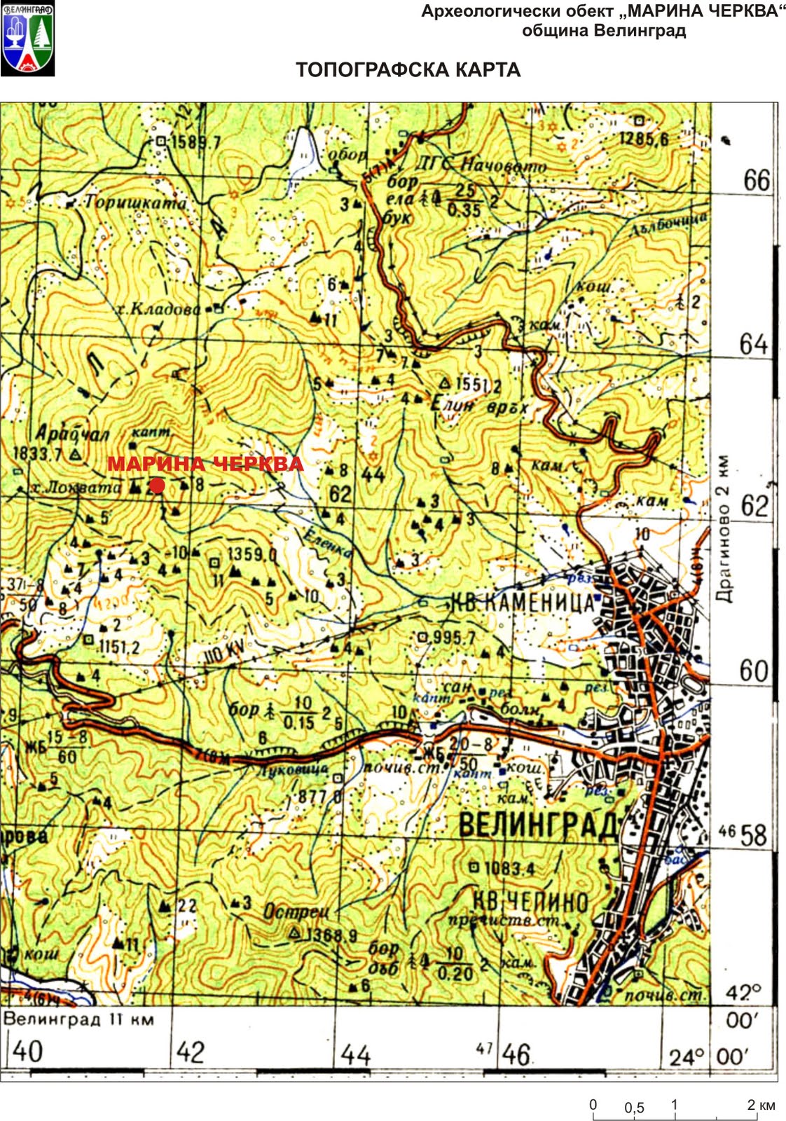
The origin of the name of the Marina Cherkva locality is of interest. According to Hristo Maslarov, who was the first to organize the archaeological meeting in the village of Kamenitsa in 1909, the name of the area comes from the ruins of a church found there which had been destroyed when the Turks had invaded the Rhodope Mountains. Stone ruins can indeed be seen in the area, which could definitely belong to the old church.
In the Eastern Rhodope Mountains and Strandzha Mountain, the cult of St. Marina has been dated a lot earlier as back as before Christianity had come in the region. A similar analogy sounds feasible and gives grounds for the ritual practices performed in the western Rhodope Mountains about one thousand years B.C.
Figure 6b:

Although the research of these high mountain monuments, which can definitely be considered as rock sanctuaries, is still in its early stages, some results are already present. The localization of the archaeological sites, as well as the primary archeological research carried out shed light on how these rock-cut monuments had appeared and functioned in the late Bronze Age. The main objective of the future research will have to focus on the analysis of the cultural, historical, and typological connections between these ritual sites in the Rhodope Mountains, including the Slaveeva Skala monument. Future archeological, archaeo-astronomical, and geophysical research will prove or disprove the conclusions that have been drawn so far.
Figure 6c:

In conclusion, the act of the official adding of the Slaveeva Skala monument, which I define as a sanctuary, on the archaeological maps is a step in the widening of the traditionally researched areas related to the reverence for the rock in the ancient times. This reverence had found its expression in establishment of such places of faith. The purpose of this research was to prove that the Slaveeva Skala monument has characteristics of a ritual monument, along with its own characteristics. At the same time, its similarities to other sanctuaries in the Western Rhodope Mountains, Strandzha Mountain, Pirin Mountain and some other more distant mountain massifs were shown, too. On the basis of different geographic, typological, archaeological, and cultural evidence showing and proving some similarities, this research can situate the Slaveeva Skala monument, together with other similar sanctuaries, with which it is in some kind of connection, within the boundaries of the same zone, that of the eastern Mediterranean region.
Figure 6d:

Bibliography:
Arnaudov 1994: Arnaudov, Al. Iz minaloto na Severozapadnite Rodopi. – In: Slavievi gori. Sb. t. I. Pazardjik. (in Bulgarian)
Bayrakov 2005: Bayrakov, D. Skalno svetilishte (“sveshtena teritoria”) v mestnostta “Slaveevi skali” – Zapadni Rodopi. – In: International conference: “The rock-cut sacred places of Thracians and other Paleo-Balkan and Ancient Anatolian Peoples.” 2-6 Nov. 2005, Stara Zagora. 2005 г. (summary).
Gergova 1980: Gergova, D. Trakiiskata drevnost v Zapadnite Rodopi. – Rodopi, kn. 3. (in Bulgarian)
Gizdova 1990: Gizdova, N. Trakiiski obekt na krepostta Cepina. – In: Trakiiskata kultura v Rodopite i gornite porechia na rekite Marica, Mesta i Struma. Smolian. (in Bulgarian)
Dermendjiev, Valev, Kaloianov 1988: Dermendjiev, Vl., P. Valev I St. Kaloianov. Parvichna dokumentacia i interpretirane na skalnite vdlabvania v mestnostta “Kozi kamak” v Zapadni Rodopi. – In: Interdisciplinarni izsledvania. XV. (in Bulgarian)
Domaradzki 1986: Domaradzki, M. Rannotrakiiska keramika ot kultov obekt v m. Skaleto pri s. Crancha, Blagoevgradski okrag. – Archeologia, XVIII, kn. 2. (in Bulgarian)
Domaradzki 1994: Domaradzki, M. Svetilishte na vrah Ostrec pri Velingrad. – In: Slavievi gori. Sb. t. I. Pazardjik. (in Bulgarian)
Domaradski, M. et al. 1999. Pametnici na trakijskata kultura po gornoto techenie na r. Mesta. Razkopkii prouchvania, XXVI. (in Bulgarian)
Zoinski 1983: Zoinski, Il. Pazardjishki okrag. Patevoditel. Sofia. (in Bulgarian)
Kanev 2009: Kanev, G. Estetika na relefa – chast ot geografskoto obrazovanie i resurs za ustoichivo razvitie. – Geografia, 21-26. (in Bulgarian)
Leshtakov 1990: Leshtakov, Kr. Ukrasa na kasnobronzovata keramika ot vrah Alada v Iztochnite Rodopi. – Archeologia, kn.1. (in Bulgarian)
Salkin, Bayrakov 2009: Salkin, A. i D. Bayrakov. Sondajni prouchvania na vrah Kaleto, grad Velingrad. In: NAIM-BAN-AOR prez 2008 g. 2009 g. Sofia. (in Bulgarian)
Salkin, Bayrakov 2009: Salkin, A. i D. Bayrakov. Sondajni prouchvania na skalno trakiisko svetilishte v m. “Slaveeva skala” – Velingrad. . In: NAIM-BAN-AOR prez 2008 g. 2009 g. Sofia. (in Bulgarian)
Salkin, Bayrakov 2010: Salkin, A. i D. Bayrakov. Terenna arheologicheska ekspedicia – “Velingrad 2008”. – Sb. Cepina, Chepinsko, Velingrad – hiliadoletnata istoria na Severozapadnite Rodopi. Velingrad, 23-34 okt. 2008 g., Sofia, 2010. 15-22. (in Bulgarian)
Record 1990: 103, obekt 40-42. In: Trakiiskata kultura v Rodopite I gornite porechia na rekite Marica, Mesta I Struma. Smolian. (in Bulgarian)
Tonkova, Gozev 2008: Tonkova, M., Al. Gozev. Trakiiskoto svetilishte pri Babyak I negovata arheologicheska sreda. Sofia. (in Bulgarian)
Fol 2007: Fol, V. Skalni toposi na viarata v Iugoiztochna Evropa i v Mala Azia prez drevnostta. Sofia. (in Bulgarian)(English summary)
Cholev i kolektiv. 1968: Cholev, M., P. Petrov, A. Shopova i Iv. Angelov. Chepinski krai. Velingrad. Plovdiv. (in Bulgarian)
Lozanova 1991: Lozanova, Galina. Mortuary feasts among the South Slavs. – Bulgarian Ethnology, N 1.
[1] The presentation of my graduation thesis took place in July 2003 in the Department of History and Cultural studies at the “St. Kliment Ohridski” Sofia University.
[2] The Archeological Map of Bulgaria is compiled by the National Archeological Institute and Museum affiliated with the Bulgarian Academy of Science.
[3] According to excavators I. Panayotov and N. Gizdova – a village, most probably a sanctuary; oval clay tools, fire pits, fragments from a cult fire pit from the early Iron Age, partially affected by Roman Late Antiquity buildings (Record 1990: 103, exhibits 40-42.
[4] The excavation camp is 1130 meters above sea level.
[5] Special thanks to Atanas Kamenarov, the engineer who took geodesic pictures and who is the author of the documentation.